
Squamish to Sunshine Coast Trail
 Vancouver July 2018
Growing up in Vancouver, I had always assumed the Sunshine Coast was an island. In my mind, anything that is only accessible by ferry had to be one. On further investigation, maps revealed it was firmly connected to the Mainland and even had a network of logging roads crisscrossing it. A google search brought up a fabled road link long since overgrown. Google maps satellite view revealed a possible route.
I set out with a friend on “disposable” bicycles; cheap second hand clunkers we could abandon if we ran out of road. To get across the Squamish River at the end we had a packraft. We had three days and it was a solid plan that failed miserably. We approached from Gibsons but quickly ran out of road after Port Mellon. We tried to take what looked from google maps like a possible coastal link under the power lines to McNab Creek, however it was anything but; it quickly became cliffy and we were forced into the steep thick forest. We carried our bikes deep into the woods before abandoning them. Each bike was left with a laminated note imploring the finder to email us and tell us what became of the bike. Only one bike was ever found. Soon it became too much on foot so we used the packraft to paddle to the McNab Creek Forest Service Road. That too turned out to be a dead end and we ended up hitchhiking out on a Spot Prawn fishing boat. It was very clear why the government had never built a road this way.
Years later I made a successful attempt with Don Barthel this time from the Squamish side. We used a packraft to access the pipeline route that climbs up and over to Woodfibre. After rafting across the Squamish River near Squamish, our night start had us attacking most of the steep bushy slope of the pipeline in the dark. We encountered a confused deer who “led” us by staying just 20 feet in front of us for most of the climb. It was so steep, the old cables that the tractors used to winch themselves up and down the slope were still in place.
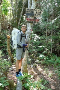
Our first successful attempt
The morning (after camping) saw us in Woodfibre. The custodian there was quite hostile as from the water it is very clearly marked with no trespassing signs. He could not believe we hadn’t come in by boat. Once he accepted our story he became much more amiable. Apparently the pipeline route is kept trim by men helicoptered in every couple years to chop down the growing trees. They never go up, only down as it is too steep. The rest of the route along the pipeline was tough but fairly straightforward. After two nights we made it to Port Mellon mission finally accomplished.
Fast forward a few years to a local newspaper article on a new Squamish to Sunshine Coast Trail. The newspaper and the group’s Facebook page revealed a completely different route then we had used. Always ready for a challenge, Don Barthel and I set off again with a lot of research and gear under our belts.
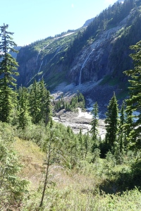
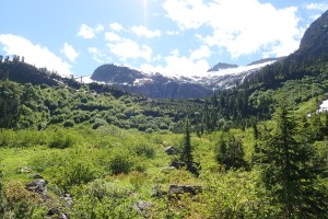 The route up and over Pokosha Pass is sublime. It equals or surpasses any of the other hikes in the area. A plethora of waterfalls tumble down from on high as the route passes over boggie bits and meadows. Although built for mountain bikes, you would have to be a serious hardcore rider to bike up or down. We had pictured some thing you could pull a bob trailer over but nothing could be farther from the truth. After the pass, mud slides have obliterated the trail and markings. The soft mud insulated layers of snow underneath. This felt like true wilderness. A marmot lazily sat on a rock sunning himself as we passed. Further along the wildflowers had further obscured the trail. Waist deep flowers made for treacherous footing down into deep gullies.
 It doesn’t take too long to connect with logging roads on the other side. Although overgrown they could easily be trimmed back to make for a fast easy trail. From here it is a long walk to Clowhom Lake where we made camp at 10:30 pm. We had left the trail head at 8am; a long day exacerbated by exploration of an old mine on the other side.
 We had hoped to do the trail in two days and one night so we started early. Another few hours walking brought us to Sechelt Inlet where a relatively fresh logging cut and now deactivated road brought us to within a couple kilometres of the Sechelt Creek Power Plant. Unable to find any trail flagging, we bushwhacked in steep terrain until cliffs pushed us low to a dead end. Only contour lines on the GPS saved us. My open maps program on my phone being relatively useless without any roads or trails of note anywhere between Pokosha Pass and the Rainy River Forest Service Road. So few people come this way that nobody had bothered to input the data yet.
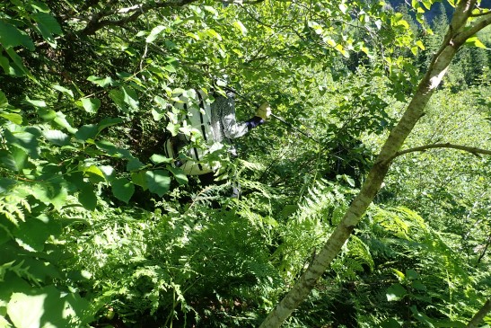
Some of the less thick bush
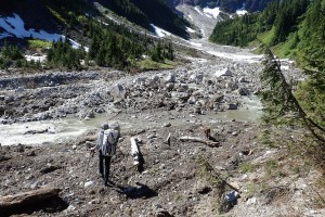
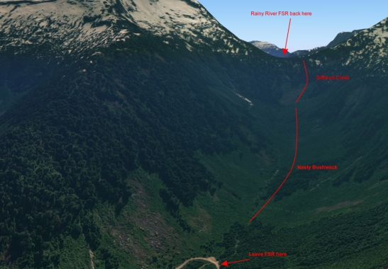
We had to retrace our steps and stay high to avoid the cliffs until we picked up flagging again on a rough but scenic trail through thick moss to the power station. Here once again we slogged ahead in the hot sun on logging roads gaining 600m to a relatively short 1.6 kilometre gap to the Rainy River Forest Service Road. Here was the crux of the trip. The valley deadened in cliffs 200 meters high which in winter must get hit by constant avalanches. The resulting flattened slide alder, berry bushes and devils club were a nightmare to bushwhack through. The tempting wide open old growth forests generally went in the wrong direction and the easier boulder fields were occasionally so giant that
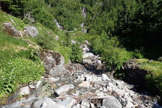
Easiest way up the valley
they became impassable with out bouldering skills and the possibility of a debilitating fall. The only “easy” way was to boulder up the stream bushwhacking around waterfalls. This brought us to the head of the valley surrounded by cliffs. At this point our GPS malfunctioned, the map and contours disappearing from the screen. Thankfully Don had memorized the best and only seemingly viable route. Up up up it went as more of a tree climb than hike; our arms working as hard as our legs. Only the best trail builder could build anything here. It is the sort of trail that seems impossible even after you make it to the end. Without flagging we went by feel, scrambling up rocky faces on occasion dodging around cliffs. It felt untouched and untrammelled with no sign of human sullying. It took 5 hours to do that 1.6 km. At the top we once again picked up flagging through old growth through to Rainy River and an eventual camp spot at 10:30 at night. We were basically out.
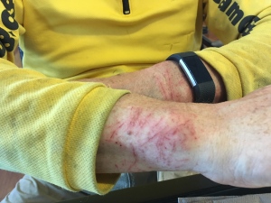
Bushwhacking injuries
The route can only be defined as long and gruelling but with great potential. At the moment your average recreational hiker would probably take five days if they had the skills to route find and bushwhack through. Security at Port Mellon told us we were only the second people they had ever heard of to complete the route the first being a year ago. Although untrue (we had talked to them the first time we completed it several years ago) it gives you an indication of how few people actually do it. Apparently a lot of people attempt it and retreat with their tail between there legs according to the woman on security. It’s about time somebody built a trail to link these two places so close to Vancouver, but at the moment I wouldn’t recommend it to anyone but the most hardy and experienced adventurers.
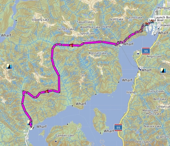
Photos and maps by Don Barthel
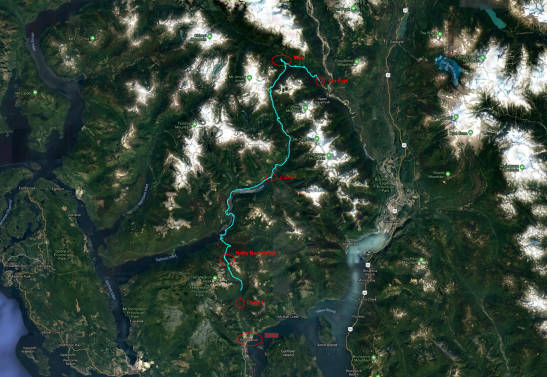
Our most recent route along the “trail”

Did I give you those throw away bikes?
Sent from my iPhone
>
You sure did. Only one has ever been found.
I am very intrigued by your story. My brother and I have had interest in hiking around the Gibsons/Squamish area. I’ve taken a look on google maps and google earth and can’t quite seem to find where the pipeline is. I did find an online map, however it just draws a line and I can’t see where it goes on the way to woodfibre. Is the pipeline somewhat above ground, and could you elaborate more on how overgrown the trail you went on was.
Thanks for your comment. You should be able to see the swath of forest maps on Google maps satellite view. It literally is just a line that goes over all the terrain as straight as possible. The pipeline is underground nevertheless they trim the trees and the bush every year or so. Once you find it it is quite easy to follow. The trouble is finding it as you need to cross the Squamish river and then bushwhack up to the pipeline.
I did this many years ago so I can’t remember exactly what it was like but it should still be doable. It is not an easy trip. Good luck and let me know how it goes.
Tyson
https://tysontravels.wordpress.com/
>